The digital twin platform for industrial-scale work.
MightyTwin brings BIM, GIS, survey, and sensor data into a single 3D environment for renewable energy, mining, and construction teams. Visualise, analyse, and act on your spatial data — through one platform.
- IFC coverage
- 2x3 — 4.3
- Median convert
- < 30s
- Output formats
- 4
Built on open standards. Compatible with the tools your team already uses.
Mighty Twin, Mighty Sheets, Mighty Converter.
Mighty Twin and Mighty Sheets are in active development. Mighty Converter ships today and comes bundled with both — or use it on its own.
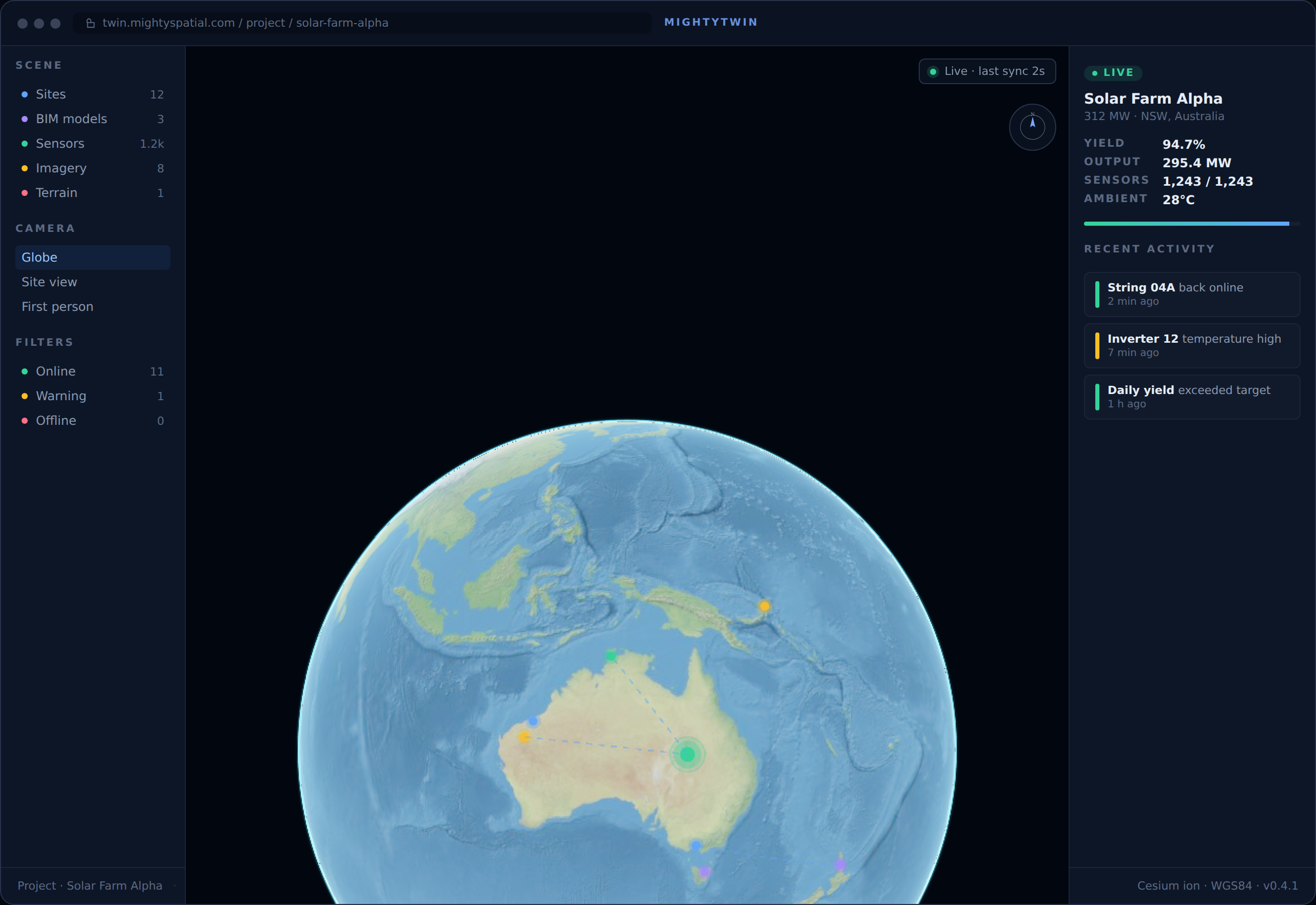
Twin · Spatial digital twin
Mighty Twin
The spatial digital twin platform for ops and engineering teams.
Cesium 3D viewer with attribute tables and an extensible widget framework, on a PostGIS backend that stores geometry in your projected CRS — survey-grade, built for operations and engineering.
- Cesium 3D viewer with attribute tables, layer styling, and an extensible widget SDK
- PostGIS backend with CRS-native storage (MGA2020, UTM, BNG) for survey-grade precision
- Includes Mighty Converter for IFC → GIS data ingest
- Available on-prem for enterprise clients
Sheets · Spatial spreadsheet
Mighty Sheets
A spatial spreadsheet with a visual canvas.
Compose pages of widgets bound to a typed SQLite database that’s all yours. Drop in a sheet, a 3D globe, a chart, a schema diagram — drag, resize, share. The data underneath is real geometry, real types, real SQL.
- Infinite-canvas pages — sheets, pivots, charts, schema diagrams, 2D maps (Leaflet), and 3D globes (Cesium) side-by-side
- Real types with first-class geometry — reprojection that doesn’t mutate your source
- Your workbook is a plain .sqlite — open in DBeaver, pandas, DuckDB, any SQLite client
- PWA + Tauri desktop + Capacitor mobile — same UI, install or don’t
- Includes Mighty Converter for IFC → GIS data ingest
Converter · Live
Mighty Converter
World’s best-value IFC → GIS converter.
Drop in an IFC, get clean GeoJSON / GeoPackage / Shapefile / FileGDB out — with auto CRS, full property transfer, and true 3D geometry.
- Free for small files; $2 for a 100 MB IFC; Pro from $100/mo with credit roll-over
- Auto CRS detection from IFC metadata — handles EPSG, georeferencing, rotation
- REST API + OpenAPI + MCP — automate from QGIS, ArcGIS, PostGIS, or Claude
- 1,750× cheaper than FME enterprise; 15× cheaper than the next online converter
Industries
Purpose-built for the industries that build the world.
Five sectors, one platform. Pick a discipline to see the workflows we’ve built for it.
Earth · Mars · Moon
Space
We have the technology to visualise your capabilities — from launch site planning here on Earth to surface operations on Mars and the Moon. Same digital twin, different ellipsoid.
Spaceport site analysis
Exclusion zones, range safety overlays, wind & EM corridors, and overflight constraints — modelled against real terrain.
Launch & trajectory simulation
Abort footprints, downrange hazards, and recovery operations visualised on a live globe.
Off-world mission planning
Traverse routes, comms windows, and terrain hazard mapping for lunar and Martian surface ops.
Mars · 2k equirectangular surface texture
Moon · 2k equirectangular surface texture
Surface textures © Solar System Scope (CC BY 4.0). Production missions wire higher-resolution USGS / NASA mosaics.
The world’s best-value IFC → GIS converter.
Free for small files. $2 for a 100 MB IFC. Compare that to $30 elsewhere, or $3,500/yr enterprise tools. Same auto CRS detection, full property transfer, true 3D geometry — purpose-built for production BIM-to-GIS pipelines.
- Automatic CRS detectionReads coordinate reference systems directly from IFC metadata. Handles EPSG, georeferencing transforms, and rotation.
- Full 3D geometry preservedTrue Z-coordinates and volumetric shapes — not just 2D envelopes.
- Property transfer (two-pass)Every IFC property set and quantity is carried through to the output format with zero data loss.
- Pipe & flow segment aggregationDisconnected segments are intelligently assembled into continuous, queryable polylines.
# Convert IFC → GeoPackage
curl -X POST https://api.mightyspatial.com/v1/convert
  -H "Authorization: Bearer $API_KEY"
  -F "file=@warehouse.ifc"
  -F "output=geopackage"

# Response
{
  "job_id": "job_8a4f",
  "features": 422,
  "crs": "EPSG:7855",
  "download_url": "…"
}Built for the way enterprise teams actually work.
From data handling to deployment, the platform is shaped around the controls that procurement, security, and engineering teams need.
We don't keep your files
- Files processed in isolated environments
- Deleted immediately after conversion
- No model data retained or shared
Deploy where you need to
- Hosted SaaS with regional server selection
- On-premise deployment available
- Desktop and Python library for offline use
Integrates with your stack
- REST API + OpenAPI specification
- MCP server for AI-agent workflows
- QGIS, ArcGIS, FME, and PostGIS compatible
Two ways to begin.
Try the converter for free, or talk to us about a custom digital twin engagement.